A day to be remembered or forgotten?

Last Monday completed 74 years the Japanese attack on Pearl Harbor, one of the most painful days of American History. I share with you here a link that brings a collection of dramatic photos, many of them rare, showing the devastation caused by the attack on the airfields of the island. Visit the link below and answer the title question.

http://aviacaoemfloripa.blogspot.com.br/2011/01/o-dia-da-infamia-em-fotos.html

Best Regards!

The fifth photo of 33 planes flying towards the camera from Diamond Head is not from 7 December1941, or even from 1941, nor are they Japanese planes.

The planes are all twin engine.

The Japanese planes launched from aircraft carriers to attack Pearl Harbor were all single engine Zeros, Kates and and Vals.

I think there was no largish scale twin engine offensive launch from an aircraft carrier in WWII until the Doolittle Raid, some months after Pearl Harbor. The Japanese certainly didn’t launch 33 twin engine medium bombers from aircraft carriers to attack Pearl Harbor.

On the face of it the photo looks like Japanese propaganda with planes inserted into the landscape when it was unlikely that such a neat photo would have been taken during the mayhem in the Pearl Harbour attack, but in fact it was a pre-war photo of American B18s taken in April 1940. See Fig. 103 at Hawaii Aviation

There is also the problem that the photo shows the planes approaching Honolulu over land from Diamond Head, but the Japanese attack in that area came in from the sea well south of Diamond Head so could not been photographed coming in over land.

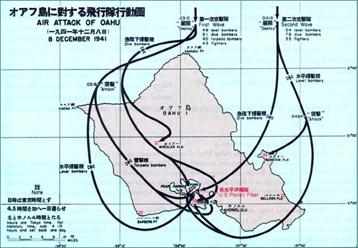
Rather than get into map references on the indistinct map below, Diamond Head is the bump below “fic Fle” in “Pacific Fleet”, with the line below it showing the Japanese approach.

haha… because of the neat order I also thought that there must have been not quite right.

But running the picture thru Google picture search you get that there are dozens of websites that connect this picture with dec 7th 1941 too.

https://www.google.nl/search?tbs=sbi:AMhZZiuDgnOYddzgB3zAF870WSdrj5c2iLN5Zmw3W9DQLjzMAQ0MAUCRN0DGWD0L6PUde9n5txNokA2gI6EvOxLD8mkapxvXEws3DgErJrqoELZUsAy3GaGmllzefKfbrv6CBxjXDOlHl4p3o9zcWCZh8DjAa7t4OPPeQiDTu7Q2heARtg6mwrhSuHtu_1hpdrI6D-79BxZCafmveM9mgWb6kofPejh0hM2kLhkQaAtUKBiNFkbKkR_1cWv1eNKPG-iKUS_1zFQ1oNYyx9mbciv6MTzUHFbY8_1JcnxmOe5IZ1b2EVjtElaWlsqxUV0I4RtJHa5DxC4HgSqYEiXDM-rCtbv3MEs9ulCcbyUNxzJK0SPTzRD0VCJdYyCVc5TMiL178UoVnMtiT6Xt_1IaiFRDEN3BVkQnuNYGpaSaNZa1EukaTsL_1FlMxXvi0dRwcQ73vdOAY6AFNoNam340f9Oq6Lq4NIsgEiykvdLNbEH7URuXpg2D7D3MDjH-4Goe_1k1Dtd5EWOCS0-EFocIQ1N8KBX-LC_1q9jhhd8chuXT0zL45oOBMuxq-XNmnGKuFSORaj1vi-h_1lg27eBZNeWQ7H9arxtX7ofMGOLWlqWWAy2YjaM1_1g8umPmaL_1Bc_1p0MRyZgoEOKfG2lnvgCQ0r3Sy9GFlxiYOib38K_1NNB7fJhPqvlzy-AW9j-RNVUgL1T_1udhp--nhFzlNyA1W-bSlbSBSBYtAgacsUPLinR3GZ7RBbv4nli8TXBSaAK_1lvogrkUJqdTiqd8p9ySH0Ac7TfoIVWIAQxIVBrUuIqjh0-acKlaGLrV5-MHDtAeD6I6Id6gpGceOJo49JSBrcwK7aW-G2oSb17JWTaHNDwsNN6ztx-2nP1xqXADcPxddHItAlMCgEXdZKTaDdtmAFVntmtQ_1hpfqAtLSot3yAb7KWmT_1IQHPLNivllh4-URB73lfUc_1TzEMk_1Lu0FNEfuzinAMYQ_1L5RJgU28CWSYhgq11MEjhR--0aG7ym7JpAdHQd2Ts0k_1r3S_1Y9vtY9WAc0gglnc52YPn25U906Dd20D2y8tx5Pndqio2afs2DiKPvmxiFSwmjCjIEGx-_1uUWsorwZoJUpt4mCTgbwuV12pWlYZsjqsyqm7oPu5SGjuhXj22DRqzQf4tPdskZuSxtSJ76g9OU3uHFy9mtdp5qiTP_1juhYA89AdLSII_1lznNpxm_1khsmrei3FqEGYwo7SAzwJPBRghSmuLmjLIAu2cAkHsvaLLuIqRS7iMsLkyhrAIPY0KZcbdFDZBFLIhQMoEz6kNfqYgSw_12oDmLghCpLL6VOJBGUhPdA-ef9WDrlMNCjbJM7On5l6rgm99XyOVVqpLeA4HH8OphZG7fTI00I5iCo7tZ_1yPsEkevSmXeQJeI3ymRTYBuqldgzTE1ljosAcPEmg1h98JYmzEGhACUmqMUC82jZReb2hb89yw3kGIdxe_1Pe76Q8MMBwGotZ1Fc44VW2mPN0e3T6ut4nI8nmFwe0Hh91IWRPf9AWZk9vaBn9s4yp3QWxjsDU9J88CXC_1ILdDZcczT3rBzPojiG0OJU2vwLcWBPv5_1_157BFhnkOQoiRdcAOWl8HgqAItWuQERYHVBQ-HP5TmogdqifhA1EN039RaLNIT66Kls3tb7u8fSbyybb0PwhLFp-IqXjP_1A&hl=en-NL

Actually , here on GoogleMapview there is a viewpoint from an airplane from AirPano com (just under Magic Island lagoon) that is some 1 mile west of diamond head and shows the (nearly) EXACT viewpoint.

https://www.google.nl/maps/place/Pearl+Harbor,+HI+96706,+USA/@21.2812388,-157.8465248,3a,66.8y,-230.97h,90.42t/data=!3m4!1e1!3m2!1sKnr7K3Ay__IAAAQfCa3upg!2e0!4m2!3m1!1s0x7c006fa0222535c1:0xab92847a3fc39777?hl=en

Hence the flight path of the twin engine in the picture agrees with the flight path of the 54 japanese level bombers in your honolulu map.

Hmmmm.

Still the sharpness of all bombers is remarkable, and thus suggests propaganda scam.

What’s missing is the point above ground of the lead or last planes if we want to fix their location exactly.

Going on a wingspan of about 80 feet, the first and second ranks are separated by several hundred feet which gives a very rough total of about half a mile for the column.

Add in lens focal length distortion and who knows how long it really was and where they were above ground points?

I don’t see how the seaward Japanese flight path could be interpreted as coming over Diamond Head as oriented in the photograph, which is looking towards the land rather than out to sea.

Anyway, the twin engines in the photo clearly have nothing to do with the Japanese attack by single engine aircraft.