
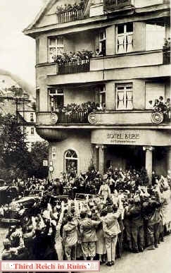
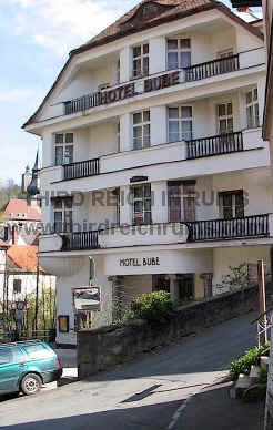
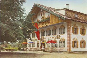
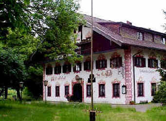
Adolf Hitler was a big fan of Richard Wagner’s music and operas, and he never missed the annual Wagner Festival in Bayreuth. During the festival, and on his trips between Berlin and Munich, Hitler often stayed at the renowned Hotel Bube in Bad Berneck, just north of Bayreuth. The building remains virtually unchanged today.
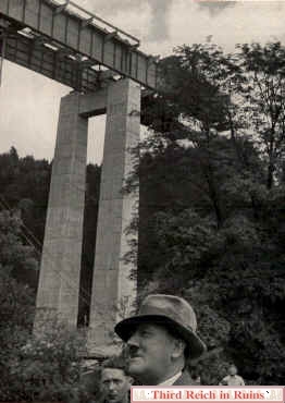
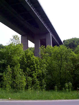
The bridge over the Mangfall river valley southeast of Munich was the first long bridge in Hitler’s Autobahn highway system. The Autobahn between Munich and Salzburg was important to Hitler, as he traveled that route often, and it passed through the part of Germany he had adopted as his home (Oberbayern - Upper Bavaria). Hitler took a special interest in the Mangfallbrücke, which was 330 meters long and 68 meters high. On the left, Hitler visits the nearly-completed bridge in the summer of 1935. The bridge was blown in April 1945, but rebuilt (with a third pylon added to each support, to widen the highway). The Mangfall Bridge is just west of Exit 98 on Autobahn 8 at Weyarn. It’s not very impressive as you drive over it - it needs to be seen from the valley below to be appreciated. (“Adolf Hitler - Bilder aus dem Leben des Führers,” Cigaretten-Bilderdienst, 1936)


A side view of the Mangfallbrücke appeared in Gerdy Troost’s architectural book Das Bauen im neuen Reich (Vol. 1, 1942 ed.). In April 1945 the Mangfall Bridge was blown by the retreating German forces.
Another of Hitler’s favorite inns was the Lambacher Hof, on the north shore of Chiemsee lake between Gollenshausen and Seebruck. Before the Munich-Salzburg Autobahn was completed, Hitler often traveled the old road past Chiemsee during his trips between Munich and the Obersalzberg, allowing a stop at the Lambacher Hof. This inn is where Eva Braun’s parents first met Hitler in 1933.
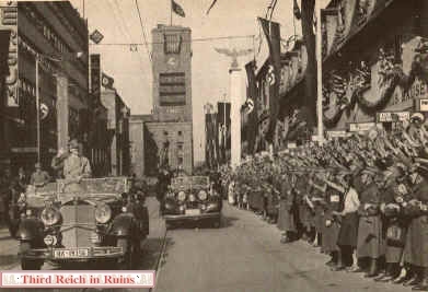

Adolf Hitler visited Stuttgart in March 1938. His motorcade drove down Königstraße from the Hauptbahnhof. Trees grow along that route today, and a Mercedes symbol replaces the swastika flag on the top of the Bahnhof tower.


Stuttgart’s wartime buildings included an air-raid shelter of a unique style. These so-called Winkeltürme (Winkel Towers) were cone-shaped concrete towers designed by Leo Winkel of Duisburg. Winkel patented his design in 1934 and began construction in 1936. Eventually some 98 Winkeltürme of five different types were built. The towers were intended mainly as protection for factory workers and railroad personnel, and they appeared most often in areas of heavy industry and rail centers. The Winkelturm in Stuttgart, a Type 2, is in the Feuerbach rail area. The cone shape was designed to defeat bombing attacks by deflecting bombs off the top and sides, toward a reinforced area around the base. However, a Winkelturm of this type in Bremen suffered a direct hit by U.S. bomb in October 1944, which exploded through the roof and killed five people inside. Click here to see other Winkeltürme in Giessen. (see Michael Foedrowitz, “Die Luftschutztürme der Bauart Winkel in Deutschland, 1936 bis Heute,” Waffen-Arsenal Band 175, Podzun-Pallas-Verlag, 1998; also http://www.luftschutz-bunker.de/winkel_tuerme.htm)
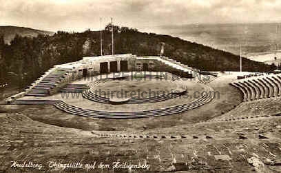

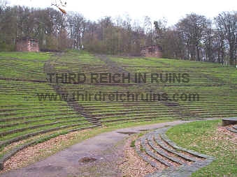
The Heiligenberg (Holy Mountain) overlooking Heidelberg was the site of an unusual Nazi edifice - a “Thingstätte.” In early Nazi quasi-religious Völkisch ceremony and Blut und Boden (Blood and Soil) ideology, a “Thing” was an open-air gathering of the people, harking back to old Germanic pagan gatherings. Some 1200 “Thing” sites were planned, but only about 40 were built, as the Nazi hierarchy lost interest in the “Thing” movement in 1936. Another such site that remains today is the Dietrich-Eckart-Bühne adjacent to the Berlin Olympic Stadium.


The views above show the Heidelberg Thingstätte from the highest point of the site. At either side of the period view can be seen hexagonal flag towers (obscured by trees in the modern photo).


Current views of the flag towers near the top of the site. The remaining flagpole appears to be the original.

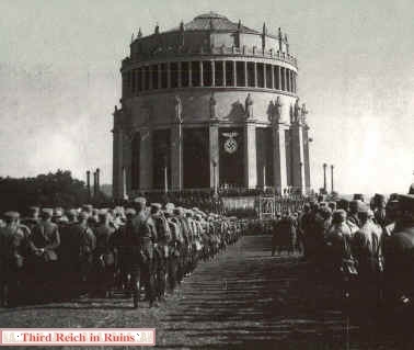
The wide-angle composite photo on the left and the plan on the right show how the Thingstätte was built as an amphitheater. The Heidelberg Thingstätte was opened officially on 22 June 1935 by Propaganda Minister Joseph Goebbels. Speaking to a crowd of 20,000 people, Goebbels called the Thingstätte a “veritable church of the Reich.”

A 1936 aerial photo, and a view looking up from the stage area today. (period postcard in author’s collection)


Two more period views of the Thingstätte from postcards dated 1935 (left) and 1939 (right). (author’s collection)
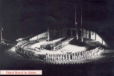

Two photos from the Heidelberg Thingstätte during its opening ceremony in June 1935. On the right, the Reichs Arbeitsdienst (Labor Service) at the “consecration.”
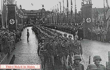

Schwetzingen is a town west of Heidelberg. The period photo shows a parade of Wehrmacht troops down the main avenue of the town in 1944.


When the 3rd and 45th Infantry Divisions of the U.S. Army moved into the Franconian city of Bamberg on 13-14 April 1945, they found the defenders fighting from the rubble produced by repeated bombing and artillery attacks. However, the defenders knew the futility of their actions and the city was quickly surrendered, sparing it from the near-complete destruction experienced in towns further west (although artillery rounds ignited a destructive fire that burned many of the older wooden houses in the city). In the photo above, tanks and infantry of the 45th Infantry Division (3/180 Infantry) clear a roadblock on Hallstadterstraße, in front of the Oehlhorn & Wöltz factory. The factory building has been changed, but practically all the other buildings on this part of the street remain much as they appeared in 1945.


GIs inspect a Panther tank (Ausf. D) parked on Zollnerstraße, near the Panzerkaserne. This had been the home of Panzerregiment 35 of the 4th Panzerdivision, and this must have been a training tank. The building, located outside the present U.S. Army Warner Barracks, is practically unchanged.
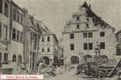

War damage to the Grüner Markt area was severe. About the only item recognizable today is the Neptune Fountain on the right, which Bambergers call “Gabelmann” (Fork Man) because of his golden trident.


Ochsenfurt, on the Main River south of Würzburg, was the scene of Nazi May Day (Tag der Arbeit) marches. The city Maibaum (May Pole) can be seen in both views, in front of the Rathaus in the distance. (Stadtarchiv Ochsenfurt)


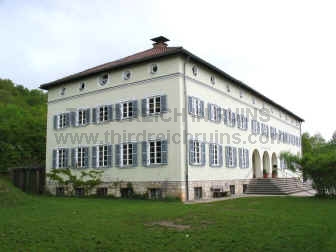
Sculptor Josef Thorak, one of the premier artists who displayed in the annual Haus der Deutschen Kunst exhibitions, had a huge studio in Baldham, a suburb east of Munich. The building was designed by Albert Speer and was described as the largest studio in the world. The studio building still exists, but is not open to the public. (Albert Speer, “Neue Deutsche Baukunst,” Berlin, 1943


Thorak’s studio figured in the German military surrender at the end of the war.
Thorak’s studio had been taken over by the advancing U.S. forces as headquarters for the XV Corps, and German General Hermann Förtsch surrendered troops of Army Group G there on 5 May 1945.
(U.S. Army Signal Corps Collection, National Archives)
The side of the building seen here is opposite the side shown in the photos above. This side is the most accessible for viewing, being located just off Waldstraße in Baldham.


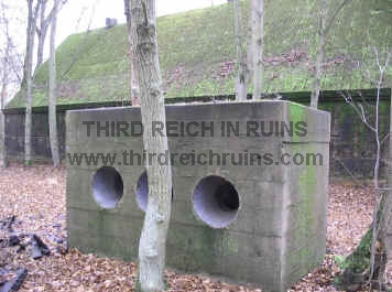
These are the remains of a Luftwaffe radar site on the border between Bavaria and Thuringia, north of Bad Königshafen in northern Bavaria. This site, built in late 1944, housed a “Würzburg-Riese” radar dish and a “Jagdschloß” radar array, along with associated administration and supply bunkers. Above - ruins of the bunker for the “Jagdschloß” radar. Below - left, ruins of the supply bunker; right, mounting base for the “Würzburg-Riese” radar dish. The period photo just below shows a “Würzburg-Riese” radar dish mounted on its base.


As the German military industries moved underground in 1944, a site was planned for assembly of BMW 801 aircraft engines. This was first known as Project “Esche 1,” then later as “Dogger.” A series of tunnels was dug into the Houbirg hill overlooking Happurg, east of Nürnberg. The planned completed size was some 120,000 square meters, but only about 15% of the tunnels were completed, and production never started. The tunnels were the standard for late-war underground construction, being arches lined with concrete. The tunnel entrances were bricked up or shut with concrete and covered over by the U.S. Army after the war. Most of the entrances are still covered with earth today - the one on the left of the lower group in the plan (seen here on the right) is partially exposed today (this is Tunnel G).


Tunnel F (next to the right in the plan) has been re-opened, but is kept locked. The photo on the right shows a view of the tunnel interior, taken through the bars of the (locked) gate.

This is the entrance to Tunnel E, covered with earth.

Higher on the hill above the tunnel entrances was a concrete water reservoir (one source says this ruin was actually a workshop building at the top of a cable lift system).


The site is now a memorial to the victims from the concentration camp at Flossenbürg, encamped nearby at Hersbruck, who died building these tunnels. On the right is a period relic found at the site - a piece of rail from the narrow gauge railway that ran to the tunnel entrances.
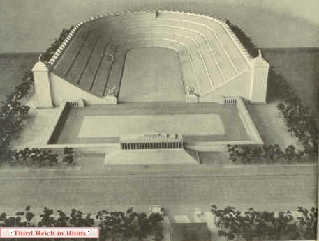

Architect Albert Speer designed the Deutsche Stadion, or Great German Stadium in Nürnberg to be the largest sports arena in the world, with seating for 405,000. The stadium (seen as an architectural model on the left) was never built, but a full-scale model of part of the seating area was built, in order to test the view from the upper levels. This model was constructed of wood with concrete foundations on a hillside in the Hirschbach valley, near the village of Oberklausen, east of Nürnberg. On the right, Speer inspects the model along with other dignitaries. The small dark rectangle seen at the top of the seating area was a block of 60 workers, testing the view. And let me assure you - the ground looks every bit as far away from up there today, as those workers looked from down below!


Speer’s Stadion would have dwarfed the other structures at the Nürnberg Party Rally Grounds, including the Kongreßhalle, seen at the upper left of the model on the left. On the right is an artist’s conception of the Stadion from ground level - the tiny people at the bottom are to scale!


Another view of the architectural model on the left, with an overall view of the full-scale model site on the right, during initial construction. (left - period postcard)


A closer view of the model site, with the corresponding view today. The trees to the right of the rock mask the series of concrete foundations going up the hillside (the lowest one is visible as a dark strip near the bottom, above the road), but the concrete bases for the separate tower can be seen near the top on the right. Apparently, the model tested two different angles for the seating arrangements, as seen on the left. The angles of the hillside for these two sections are still different today.


The wooden parts of the structure were removed by the U.S. Army after the war, but the concrete bases are left today. On the left, one of the massive concrete walls that supported the cross levels of the wooden seating area model. On the right, some of the many smaller blocks that supported the seats themselves. (The wood was used to rebuild a local village, which had been largely destroyed during a defense by SS troops during the U.S. Army advance in April 1945.)


On the left, the supports for the model of the upper rim of the stadium, above the seating area - seen at the upper left of the full-scale hillside model photo. On the right, concrete supports for the separate tower model, on the opposite side of the hill face.


The Haus der Deutschen Erziehung (House of German Education) was located on Luitpoldplatz (this part is now called La Spezia Platz) in the northern part of the downtown area. The building was substantially damaged by bombing during World War II, and was rebuilt in 1947. Subsequent renovations have changed its appearance considerably. Today the building is used by the E.ON energy corporation. (period postcard)


The long building to the left was known as the Steno Haus, but it has been replaced by modern construction. (period postcard)


Dedication of the House of German Education on 12 July 1936.


This market hall was built in Bayreuth in 1935. The fresco on the front wall was painted by Oskar Martin-Amorbach, a respected artist whose works were displayed in the Haus der Deutschen Kunst. Now called the Rotmainhalle (after the “Red” branch of the Main River), the building is almost surrounded by the modern Rotmain Center.


At the end of the war the U.S. 11th Armored Division moved through northeastern Bavaria, from Coburg to Kronach, Kulmbach, and Bayreuth, then from there to the southeast through the Bavarian Forest, and into Austria. This M4A3 Sherman tank passed through the village of Marktzeuln, southwest of Kronach, on 12 April 1945. The view is almost exactly the same today.


This M4A3 Sherman tank is advancing into the center of Kronach, which burns from the fighting, on 12 April 1945. The Fachwerk building in the center background was not rebuilt in its original style. (Many thanks to Louis Lanier Hurdle, who identified this location (which had eluded me) and sent the modern photo.) ("Thunderbolt - History of the Eleventh Armored Division (Paris, 1945)


This is not the 11th Armored Division nor northern Bavaria, but an M4A3 Sherman tank of an armored unit advancing toward Berchtesgaden in early May 1945. The tank had come from Munich (north) and was passing through the town of Miesbach, where it turned east toward Rosenheim and Berchtesgaden. A column of German POWs (including some mounted on horses) can be seen marching toward Munich.


Hitler’s planned Autobahn highway system called for three main north-south highways, linked by several east-west connectors. Some of the construction projects were halted by the start of war in 1939 - one of these was the north-south section between Fulda and Würzburg, known as “Strecke 46” (Section or Stretch 46). Several bridges had been built, and parts of the highway were ready for surfacing. However, the eventual completed north-south highway in this area, today’s Autobahn A7, was built about 20 kilometers east of the planned route of Strecke 46. So the remains of Strecke 46 can now be found along its original route. See the Strecke 46 homepage - Strecke46.de.
This was a bridge abutment for a bridge across the valley of the Fränkische Saale river, at Schonderfeld west of Hammelburg. The artifact is used today by climbing clubs, who put the cross and railings on the top.


This bridge over a small road near Burgsinn, north of Gemünden, is in surprisingly good condition today. Just passing under the bridge, one would not realize there is actually no roadway up above. This road was part of the route of Task Force Baum, whose tanks passed directly under this bridge and went on up the hill, toward Gräfendorf and Hammelburg.


One of the longest bridges in the Autobahn system was that crossing the valley of the Saale River south of Jena (on the current Autobahn A4). The view on the left above shows an architectural model of the bridge. On the right, a GI inspects a destroyed span that was blown by retreating German forces in April 1945.


The Jena Brücke as seen in 1938, with a corresponding view today.

his Jugendherberge (Youth Hostel), sometimes also described as a Hitler Jugend home, was built in Eichstätt from 1936-38 (Eichstätt is located between Nuremberg and Munich). It still serves as a Youth Hostel, located at Reichenauerstraße 15.


This building in Neustadt bei Coburg in northern Bavaria was the headquarters for the Reichsarbeitsdienst (RAD - Labor Service) Battalion 2/280 “Buchhändler Johann Philipp Palm.” It was built in 1935-36 at Feldstraße 20. The building still exists, but a comparison photo from the same angle is not possible today, and the RAD monument in the forecourt is long gone.


This building in Neustadt an der Aisch in northern Bavaria was the headquarters for the Reichsarbeitsdienst (RAD - Labor Service) Battalion 1/281 “Meister Peter Vischer der Älterer.” The building still exists, but the double tower above the entrance, with the RAD spade insignia and motto “Arbeit adelt” (Work Enobles) has been replaced by a normal gable. However, a close examination of this part of the building reveals a line where the towers were originally mounted.


Charged with finding or building a field headquarters site for Hitler, architect Albert Speer reworked a country palace at Ziegenberg, near Bad Nauheim in Hessen. Modern communications equipment was installed, in addition to well-appointed quarters, and various above and below-ground bunkers. This complex was called Führerhauptquartier “Adlerhorst” (Eagles Nest). But when Hitler saw it, he considered it to be contrary to his desired appearance as a simple field soldier (he considered it far too lavish), so another headquarters was built in the Eifel, called “Felsennest” (Rock Nest), and this is where Hitler directed the attack on the West in May 1940. During the Ardennes Offensive (Battle of the Bulge) in December 1944, Generalfeldmarschall von Runstedt used the Ziegenberg facility as his headquarters (Hitler used a small bunker facility about a mile north in Wiesental - see below). The Ziegenberg complex was bombed by the Americans shortly before the end of the war.


The bunkers built near the Ziegenberg palace had both above and below-ground components, and were camouflaged to look like civilian buildings (these bunkers are used today as a depot for the German Bundeswehr).


On the left, an air-raid protection bunker in Ziegenberg. This concrete bunker was clad on the outer walls with rough rocks (complete with fake windows), and it had a pointed roof (presumably with roofing tiles), as camouflage. Nearby is a large garage built to service the vehicles of the military staff - now a business center.


Hitler’s nearby headquarters at Wiesental consisted of several wooden buildings with underground bunkers. On the left is a wartime photo of one of these buildings. The above-ground parts are all gone now, with post-war houses built in their places. Some of the foundations of these post-war buildings are apparently from the original structures. The large building in the photo on the right sits where the Reichsicherheitsdienst (Security Service) bunker was located. The buildings behind are located on the sites for the bunkers for staff generals, adjutants, and press personnel. An artist studio now occupies the former location of Hitler’s bunker. (Bundesarchiv Koblenz)


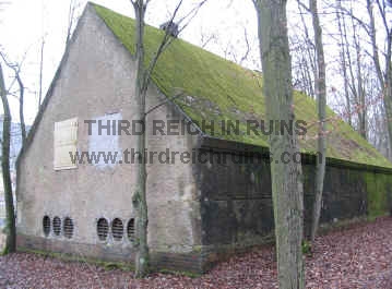
Several air-raid shelters of a unique style can be found in Giessen. These so-called Winkeltürme (Winkel Towers) were cone-shaped concrete towers designed by Leo Winkel of Duisburg. Winkel patented his design in 1934 and began construction in 1936. Eventually some 98 Winkeltürme of five different types were built. The towers were intended mainly as protection for factory workers and railroad personnel, and they appeared most often in areas of heavy industry and rail centers. The Giessen towers were installed on Wehrmacht posts - the one above was on the Artillerie-Kaserne, which the U.S. Army used as Pendleton Barracks after the war. The tower is now located on public property and is used as a climbing tower. The photo on the right shows damage from a high-explosive shell and a long crack running down the side, which may be from prior efforts to blow the tower up. The knobby projections are artificial hand-holds for climbing (the bars near the top of the tower were added to fix climbing ropes).


The Winkelturm on the left is near the one in the photos above - it has been painted as part of a childen’s recreation center in the adjacent former barracks building. The two on the right were in the Verdun-Kaserne, which the U.S. Army used as Rivers Barracks. Another Winkelturm is located on the former Berg-Kaserne.


On the left, a 1937 postcard showing the Wald-Kaserne, or Verdun-Kaserne in Giessen. The Winkel towers do not show in these views. Both of these towers were built adjacent to barracks buildings.
Part of the wartime function of the Verdun-Kaserne was to train Nachrichtenhelferinnen - female auxiliary signals specialists. This concrete bunker building was part of the “Amt Gisela” communications complex, located at the rear of the Kaserne. This bunker complex (including the nearby “Hansa” bunkers) included underground components - the photo on the right shows a protected ventilation inlet/outlet for the underground portion beneath this building.


To celebrate its 650th year, the town of Windecken (near Hanau in Hessen) held a festival with parade on 6-8 August 1938. The town was decorated with Nazi flags, and the local Kreisleiter was the master of ceremonies for the festivities. Here, the volunteer fire department participates in the parade through the Marktplatz. The buildings appear almost identical today. (period photos and info from the webpage of the Windecken History Club,


Many of the parade participants were in period costumes, representing various eras in the town’s history. Here, women in Rococo dress walk into the Marktplatz from Friedbergerstraße.


Looking out from the Marktplatz down Friedbergerstraße, toward the church.


SS “Berghaus” rest and relaxation home, on the Sudelfeld near Bayrischzell in southern Bavaria. The home, which included tennis courts and a swimming pool, was built in 1937-38. It serves today as a Youth Hostel

n 23 October 1933 the Befreiungshalle at Kelheim, overlooking the Danube River southwest of Regensburg, was the scene of a Nazi gathering of SA (Sturmabteilung) units. The Befreiungshalle was a monument erected 1842-1863, to mark the liberation of Germany from Napoleonic rule.


The Nazis held a parade through the Bavarian town of Vilsbiburg in 1927 in preparation for a speech by Hitler - SS chief Heinrich Himmler is seen leading the column. The scene today appears almost identical.


A Hitler-Jugend-Heim with Jugendherberge was built in Aschaffenburg in 1935. Post-war construction precludes an overall view of the building now - this is a composite photo.


Entering the doorway (left), and inside the bunker interior (right). Only the side walls and roof edges remain - the centers have been collapsed by demolition.


One of the work projects completed by the Reichs Arbeitsdienst (RAD - Labor Service) in the 1930s was the Hochrhönstraße, or High Road through the Rhön Highlands in northern Bavaria, near the border with Hessen and Thüringen. Several RAD camps were erected in this area to house the workmen - the largest of these was a double camp built at the northern edge of the Schwarzes Moor area near Fladungen. This camp, for RAD battalions 5/283 and 6/283 (later 1/288 and 2/288) was called the Dr. Hellmuth-Lager, for the Gauleiter of Main-Franken, Dr. Otto Hellmuth, who was in charge of the plans and construction in this area.
The camp consisted of a double row of barracks buildings with a dining hall at one end and a large training and exercise hall at the other, the whole being surrounded by a high earthen berm. The camp was entered though an archway of natural basalt stones, native to this area, built into the front of the exercise hall. This basalt archway, seen in the photos above, is the only part of the camp still standing (remains of the building foundations and the border berm can also be seen). During World War II the camp housed prisoners of war who worked in the nearby fields. The buildings housed displaced persons after the war, and the camp was later torn down. (period photo in author’s collection)


The large exercise hall (9000 square feet) can be seen in the overall view of the camp, along with the berm surrounding it. The road in the foreground is the Hochrhönstraße. The modern photo was taken inside the site of the exercise hall, showing the inner side of the entry archway, and part of the earth berm remaining in the distance. (period photo in author’s collection)

